
Cyprus: Island of Snakes, Cats, and Ophiolites
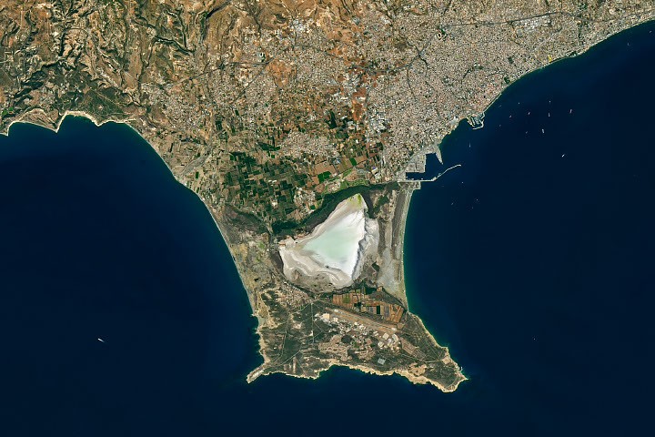
The island of Cyprus began to form some 90 million years ago during the Late Cretaceous, with molten rock pouring from the seafloor, solidifying, and building new oceanic crust. Over time, portions of this oceanic rock were wrenched upward by tectonic forces, eventually emerging as a rugged island made of ophiolite, a type of rock with a mottled green appearance said to look like the skin of a snake. Remnants of that ancient island are still visible in the dark rocks of the Troodos Mountains.
During the Miocene, considerably younger layers of chalk, limestone, marl, and other marine sedimentary rocks accumulated around the island, providing material that developed into a second, smaller island to the south during a later period of geologic uplift. Over time, sediment poured from rivers into the channel separating the two islands and combined with marine sediments to create deltas and eventually two land bridges, or tombolos. The joined landmass comprises the Akrotiri Peninsula, now the southernmost tip of Cyprus.
The sandy edges of the peninsula were visible when Landsat 8 captured these images on October 10, 2026. Akrotiri Salt Lake, a coastal lagoon that was once an arm of the Mediterranean Sea, lies between the two tombolos. The more westerly feature, the Kouris River tombolo, formed first, developing about 50,000 years ago from river-deposited gravels and sands. The eastern tombolo extended southward from Cyprus, cutting off the Mediterranean Sea only within the past 2,000 years, according to geologists.
The lake’s water levels now vary markedly with the seasons, typically filling in the late autumn and winter and drying out in the summer. The influx of winter water has historically attracted sizable overwintering flamingo populations, averaging about 4,000 birds. However, the wintering flamingo population has declined in recent years, plummeting to 30 birds in 2025, according to news reports. Flamingos have long flocked to the lake to feed on fairy shrimp, which are rich in colorful substances called carotenoids that give the birds their famously pink hue.
Snakes are another of the island’s more notorious animal inhabitants. In antiquity, Cyprus was known as Ophiousa, or “land of snakes,” likely due to its robust population of blunt-nosed vipers. According to legend, the island’s snake communities grew to be so problematic during a drought in the fourth century that the Roman Empress Helena, mother of Constantine the Great, called for shiploads of cats to be sent from Egypt to control the venomous reptiles.
The first feline imports were released in a particularly snake-infested area on the southeastern part of the Akrotiri Peninsula, an area that came to be known as Cape Gata (Cape Cat in Greek). The cape today is still home to the Holy Monastery of St. Nicholas of the Cats, a place where legend says that monks encouraged newly arrived Egyptian cats to hunt snakes. Today, Cyprus has as many cats as people, with more than one million of the feline predators stalking the island. The handful of nuns who now live in the monastery still care for hundreds of cats, according to the St. Nicholas Center.
NASA Earth Observatory images by Michala Garrison, using Landsat data from the U.S. Geological Survey. Story by Adam Voiland.
References & Resources
- AP (2025, October 14) Cyprus has a cat problem: One feline for every resident. Accessed November 4, 2026.
- Atlas Obscura Holy Monastery of St. Nicholas of the Cats. Accessed November 4, 2026.
- BirdLife Cyprus (2025, November 17) When the Salt Lakes turn pink: The Greater Flamingos of Cyprus. Accessed November 4, 2026.
- BirdLife Cyprus Akrotiri Peninsula SOS. Accessed November 4, 2026.
- BirdLife Cyprus (2024) A Review of the Hydrology & Ecology of the Akrotiri Peninsula wetlands. Accessed November 4, 2026.
- The Geological Society, Troodos Ophiolite, Cyprus. Accessed November 4, 2026.
- James, S., et al. (2021) From phantom town to maritime cultural landscape and beyond: Dreamer’s Bay Roman-Byzantine ‘port’, the Akrotiri Peninsula, Cyprus, and eastern Mediterranean maritime communications. The Journal of the Council for British Research in Levant, 52(3).
- Kyriacou, C. (2021) Saints, Sacred Trees, and Snakes: Popular Religion, Hierotopy, Byzantine Culture, and Insularity in Cyprus during the Long Middle Ages. Religions, 12(9), 738.
- Philenews (2025, February 19) Flamingo numbers in Cyprus hit historic low. Accessed November 4, 2026.
- Polidorou, M. & Evelpidou, N. (2021) Geomorphology of the Coastal Sand Dune Fields and Their Association with the Palaeolandscape Evolution of Akrotiri Peninsula, Lemesos, Cyprus. Geosciences, 11(11), 448.
- Polidorou, M., et al. (2021) Observations on Palaeogeographical Evolution of Akrotiri Salt Lake, Lemesos, Cyprus. Geosciences, 11(8), 321.
- Robertson, A. (1998) Mesozoic-Tertiary tectonic evolution of the easternmost Mediterranean area: integration of marine and land evidence. Proceedings of the Ocean Drilling Program, 160.
- St. Nicholas Center, St. Nicholas of the Cats—Ayios Nikolaos ton Gaton—Monastery. Accessed November 4, 2026.
You may also be interested in:
Stay up-to-date with the latest content from NASA as we explore the universe and discover more about our home planet.
Stewart Island/Rakiura, New Zealand’s third-largest island, is known for its vibrant birdlife, unique forests, wilderness beaches, and views of the…
The drying of the massive lake exposed playas that became the setting for feats of engineering and technological ingenuity, as…
Marshy, sandy terrain and an impassable inlet helped colonial forces repel British forces during a pivotal battle on the barrier…
Source & Attribution
This One Place News story was acquired from science.nasa.gov. OPN retains the source link and provenance for newsroom review.
Filed Under
Technology & AI