One Place News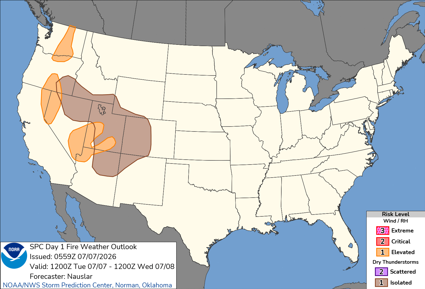
SPC Day 1 Fire Weather Outlook

Day 1 Fire Weather Outlook
NWS Storm Prediction Center Norman OK
1259 AM CDT Tue Jul 07 2026

Valid 071200Z - 081200Z

...Synopsis...
The upper-level high will begin to extend and shift westward from
the Southwest to coastal southern California. Upper-level heights
will rise across much of the West through the day, but an
upper-level trough will approach the Pacific Northwest coast late in
the period. The onshore surface pressure gradient across the
Cascades will strengthen with lee troughing to the east of the
Cascades and extending down along the northern Sierra. A thermal
trough will extend out of the Desert Southwest into the central
Great Basin.

Isolated to scattered mixed wet/dry thunderstorms will develop
across portions of the northern Great Basin and extend to the Four
Corners region. PWAT values of 0.5-0.9" associated with mostly
mid-level moisture across the region along with a deep, well mixed
boundary layer and storm motions of 15-25 knots will help limit
precipitation. A weak mid-level disturbance is forecast to move
across portions of the Great Basin, which will help increase storm
development and organization and lead to potentially severe outflow
winds.

Wetter storms are likely, especially from central/northeast Oregon
extending into northern Utah, but the IsoDryT area was maintained
given the likelihood of mixed wet/dry thunderstorms, receptive
fuels, and likely scattered thunderstorm coverage. Smoke in Colorado
into the Four Corners could inhibit thunderstorm development and
will be monitored for the Day 1 update. Isolated high-based
thunderstorms are possible overnight in portions of eastern
Washington, but too much forecast uncertainty exists to include an
additional IsoDryT area.

Westerly sustained winds of 12-20 mph gusting 20-30 mph amid minimum
RH of 12-25% are likely in portions of the Cascades Gaps onto the
Columbia Basin and from south-central Oregon extending south along
the Sierra Front. Southwest sustained winds of 12-20 mph gusting
20-30 mph amid minimum RH of 5-15% are expected across the southern
Great Basin/vicinity. These conditions will be more pronounced along
thermal trough extensions and under slightly stronger mid-level flow
(20-30 knots).

..Nauslar.. 07/07/2026

...Please see www.spc.noaa.gov/fire for graphic product...